#watch | Uttar Pradesh: Rain lashed parts of Noida earlier today. Visuals from Sector-11. pic.twitter.com/kObud2489E
— ANI (@ANI) May 29, 2025
---Advertisement---

The India Meteorological Department (IMD) has issued weather advisories for several parts of the country on Thursday, May 29, warning of heavy rainfall, thunderstorms, and gusty winds across southern, western, eastern, and northeastern India. It stated that the Southwest Monsoon further advanced into some more parts of Maharashtra, remaining parts of Karnataka, most parts of Telangana, remaining parts of Andhra Pradesh, some parts of Chhattisgarh & Odisha, remaining parts of west central Bay of Bengal on Wednesday. The conditions are favourable for further advance of southwest monsoon over some more parts of Chhattisgarh, Odisha, remaining parts of Northeastern states and some parts of West Bengal & Sikkim during next 2 days.
Widespread light to moderate rainfall, accompanied by thunderstorms, lightning, and gusty winds reaching 40–50 km/h, is expected over Kerala, Mahe, and Karnataka. Isolated heavy to very heavy rainfall is likely over Coastal Karnataka, South Interior Karnataka, and Kerala. Tamil Nadu, Puducherry & Karaikal may also see isolated extremely heavy rainfall. Thundersqualls with wind speeds of 50–60 km/h, gusting to 70 km/h, are likely over Karnataka, Coastal Andhra Pradesh & Yanam, and Rayalaseema.
The IMD has further warned about very heavy to extremely heavy rainfall likely over Northeastern states and Sub-Himalayan West Bengal and Sikkim till May 30.
Catch all the live updates, daily forecasts, and IMD alerts — only on News24.
#watch | Uttar Pradesh: Rain lashed parts of Noida earlier today. Visuals from Sector-11. pic.twitter.com/kObud2489E
— ANI (@ANI) May 29, 2025
#watch | Tamil Nadu: Several houses develop cracks due to continuous rainfall in the Nilgiris district for some days. pic.twitter.com/8xY0VYcs9u
— ANI (@ANI) May 29, 2025
A warning has been issued for the coastal areas of Tamil Nadu that a cyclonic storm will blow. With a low-pressure area forming in the Bay of Bengal, the Meteorological Department has advised that cyclone warning signals be raised at ports. Cyclone Warning Number 1 has been raised at 7 ports, namely Chennai, Cuddalore, Nagapattinam, Ennore, Kattupalli, Puducherry and Karaikal, while Cyclone Warning Number 3 has been raised at Pamban and Tuticorin ports: IMD
#watch | Tamil Nadu: A warning has been issued for the coastal areas of Tamil Nadu that a cyclonic storm will blow. With a low-pressure area forming in the Bay of Bengal, the Meteorological Department has advised that cyclone warning signals be raised at ports. Cyclone Warning… pic.twitter.com/arX1YAv9iz
— ANI (@ANI) May 29, 2025
Gorakhpur receives heavy rainfall and gusty winds
#watch | Uttar Pradesh: Gorakhpur receives heavy rainfall and gusty winds. pic.twitter.com/I3WcbBXU6W
— ANI (@ANI) May 29, 2025
Kupwara receives heavy rain and hailstorm.
#watch | J&K | Kupwara receives heavy rain and hailstorm. pic.twitter.com/XP5WU8LhDg
— ANI (@ANI) May 29, 2025
Heavy rain lashes parts of Kalaburagi
#watch | Karnataka: Heavy rain lashes parts of Kalaburagi. pic.twitter.com/lUY6iMqxoV
— ANI (@ANI) May 29, 2025
Thunderstorm accompanied with Hailstorm very likely at isolated places over Uttar Pradesh.
Heavy to Very Heavy Rainfall with isolated Extremely Heavy Rainfall very likely at isolated places over Assam & Meghalaya, Costal Karnataka, Kerala & Mahe, Nagaland, Manipur, Mizoram and Tripura, South Interior Karnataka and Tamil Nadu
IMD Issues Orange Alert In Delhi-NCR
The IMD in an X post stated: The southwest monsoon seasonal (June to September, 2025) rainfall is most likely to be above normal over Central India and South Peninsular India (>106% of LPA), Normal over Northwest India (92-108% of LPA) and below normal over Northeast India (<94% of LPA).
Updated Long Range Forecast for the Southwest Monsoon Seasonal Rainfall during June–September, 2025 and Monthly Rainfall and Temperature Outlook for June 2025. The southwest monsoon seasonal (June to September, 2025) rainfall is most likely to be ❖Above normal over Central…
— India Meteorological Department (@Indiametdept) May 29, 2025
The depression over Northwest Bay of Bengal off West Bengal-Bangladesh coasts moved nearly northwards with a speed of 20 kmph during past 3 hours, intensified into a deep depression and lay centred at 0830 hours IST of today, the 29th May 2025 over the same region near latitude 21.3° N and longitude 88.5° E, about 60 km southeast of Sagar Island, and 180 km west of Khepupara (Bangladesh).
The depression over Northwest Bay of Bengal off West Bengal-Bangladesh coasts moved nearly northwards with a speed of 20 kmph during past 3 hours, intensified into a deep depression and lay centred at 0830 hours IST of today, the 29th May 2025 over the same region near latitude… pic.twitter.com/kbs2yIJWXu
— India Meteorological Department (@Indiametdept) May 29, 2025
Most parts of South Bengal are expected to receive moderate rain/thunderstorms, with the possibility of intense rainfall in: East Burdwan, East Midnapore, North and South 24 Parganas, Kolkata, Howrah, Hooghly, Nadia and Murshidabad.
The weather will remain cloudy in Mumbai city and suburbs. There is a possibility of scattered rain at some places and heavy rain at others.
Generally cloudy sky with intermittent spells of light to moderate rain in city & suburbs.
🗓️ २९ मे २०२५⛈️☔मुंबई शहर आणि उपनगरात वातावरण ढगाळ राहील. काही ठिकाणी तुरळक स्वरुपाचा तर काही ठिकाणी मुसळधार पाऊस कोसळण्याची शक्यता आहे. 🌊भरती -दुपारी ०१:५२ वाजता - ४.७९ मीटरओहोटी-रात्री ०७:५७ वाजता - १.६० मीटर🌊भरती -रात्री- १:३१ वाजता - ४.०४ मीटर (उद्या…
— माझी Mumbai, आपली BMC (@mybmc) May 29, 2025
Wet spell and Thunderstorm activity very likely over some parts of Himachal till 2nd June, 2025.
Thunderstorm accompanied with lightning and gusty winds(50-60 kmph) at isolated places very likely over Chamba, Kangra, Kullu, Mandi, Shimla,
Bilaspur and Hamirpur during May 29 to June 2, 2025.
Gusty winds (40-50 kmph) at isolated places very likely over Chamba, Kinnaur and Lahaul-Spiti districts during May 29 to June 2.
The IMD on Thursday stated that a well-marked low-pressure area is likely to move nearly northwards, intensify further into a deep depression and cross West Bengal – Bangladesh coasts between Sagar Island and Khepupara (Bangladesh) by afternoon of today, the 29th May, 2025.
Yesterday’s well-marked low-pressure area over Northwest Bay of Bengal off Odisha coast concentrated into a depression and lay centred at 0530 hours IST of today, the 29th May 2025 over northwest Bay of Bengal off West Bengal and adjoining Bangladesh.It is likely to move nearly… pic.twitter.com/0GRpjxep9V
— India Meteorological Department (@Indiametdept) May 29, 2025

The IMD has issued thunderstorm, Lightning, Squall and heavy rain warning in several districts of Jammu and Kashmir.


Weather changes are taking place in Uttar Pradesh and Bihar. A drop in temperature is expected in western UP.
There is a possibility of rain/thundershowers at isolated places in the division on May 29.
East Uttar Pradesh:- There is a possibility of rain/thundershowers at isolated places in the division on May 29.
West Uttar Pradesh:- There is a possibility of thundershowers/gusty winds (speed 30-40 km/hr) at isolated places in the division on May 29.
At the same time, Bihar is also witnessing a shift in weather patterns. The pre-monsoon season is coming to an end. Rain is likely in 27 districts of the state. Out of these, heavy rainfall is expected in 12 districts, while light rain warnings have been issued for 15 districts.
The districts in Bihar likely to be affected include Sitamarhi, Sheohar, Banka, Jamui, Munger, Khagaria, Muzaffarpur, Vaishali, Samastipur, Madhubani, Darbhanga, Supaul, Araria, Kishanganj, Saharsa, Madhepura,
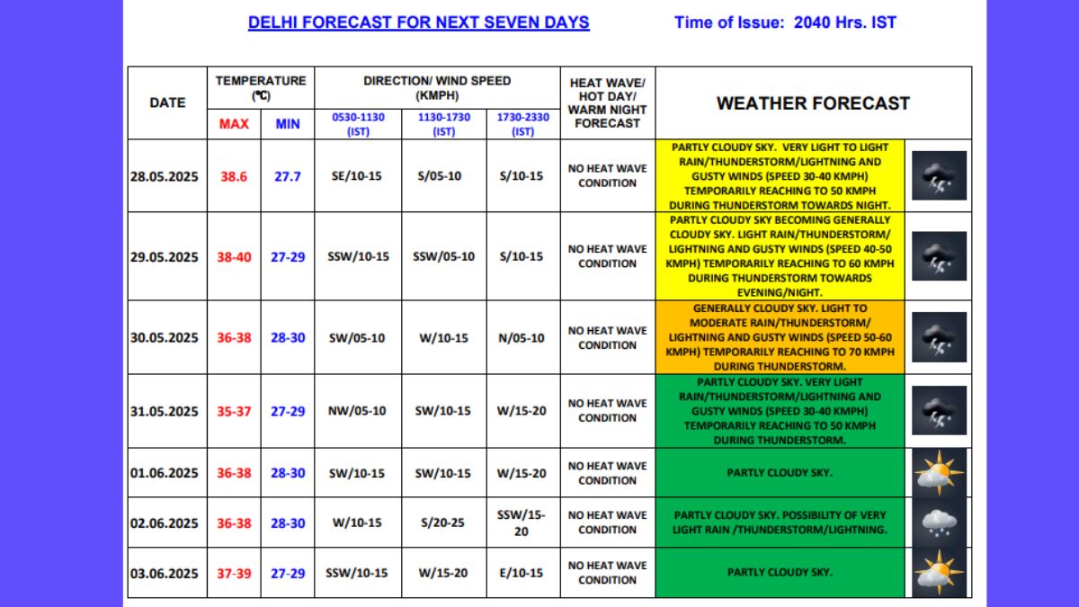
Lucknow Update: Mainly clear sky becoming Partly cloudy sky. The Maximum and Minimum Temperature will be around 39°C & 29°C respectively.
Moderate rain is predicted over Thane, Palghar, Mumbai, Raigad, Sindhudurg, Dhule, Nandurbar, Jalgaon, Nasik, Ahilyanagar, Pune, Kolhapur, Satara, Sangli, Sholapur, Jalna.
Yellow alert has been issued for several districts.
For detailed forecast check this link: https://mausam.imd.gov.in/mumbai/mcdata/district.pdf
Severe waterlogging witnessed in several parts of Guwahati after heavy rainfall in the region.
#watch | Assam: Severe waterlogging witnessed in several parts of Guwahati after heavy rainfall in the region(Visuals from Rukmini Gaon area) pic.twitter.com/eidWOq14lW
— ANI (@ANI) May 29, 2025

Heat wave conditions are very likely in isolated pockets of West Rajasthan on May 29.
Widespread light to moderate rainfall is likely across the region. Isolated extremely heavy rainfall is forecast over Assam & Meghalaya, and Nagaland, Manipur, Mizoram & Tripura.
Get Breaking News First and Latest Updates from India and around the world on News24. Follow News24 on Facebook, Twitter.
---Advertisement---
IMD Warns Of Heatwave In Rajasthan, Punjab, UP And More From June 9-11

---Advertisement---